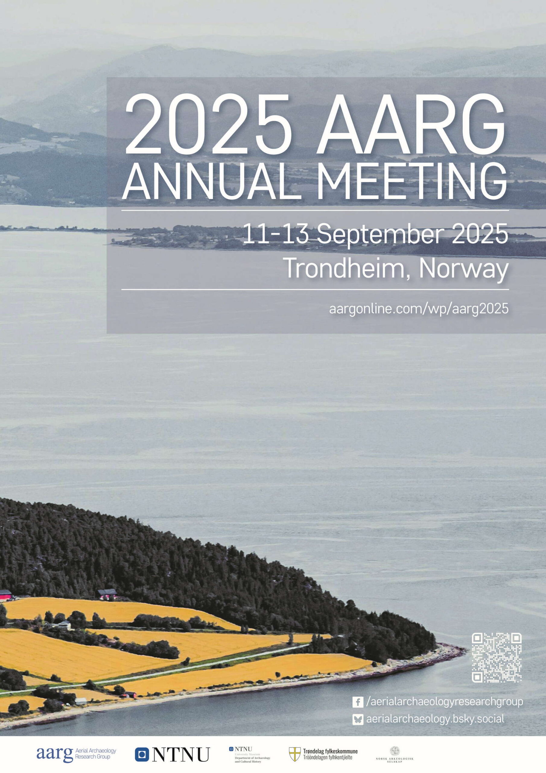
Aerial Archaeology Research Group
2025 Annual Meeting
Trondheim, Norway
11-13 September, 2025
The AARG Committee is thrilled to announce the 42nd AARG meeting will be held on the 11th and 12th September 2025 in Trondheim, Norway followed by a field trip on the 13th September 2025.
The conference is organised jointly by AARG and the Department of Archaeology and Cultural History of the Norwegian University of Science and Technology, with financial support from Trøndelag County Municipality, NTNU University Museum, Department of Archaeology and Cultural History and the Norwegian Archaeological Society.
We have an accessible and capacious venue at the Dokkhuset located on the vibrant waterfront just outside the old town, a short walk from the Nidaros Cathedral dominating the skyline of Trondheim. The venue is within reach of the range of accommodation options and the main train station.
Themes
We invite proposals for oral presentations (20 mins) and posters (A1 portrait) aligning with the following themes:
The theme will feature papers on aerial archaeology and remote sensing primarily in the Nordic countries but also across the circumpolar and subarctic regions. Papers may include airborne and spaceborne prospection of prehistoric and medieval landscapes covered with tundra, taiga, or boreal forest as well as examples of research investigating modern industrial or military heritage.
Processes such as rising sea levels, more frequent and powerful storms, and accelerating desertification on the one hand side as well as urban sprawl, intensive farming, military conflicts, and mass tourism on the other are affecting even more communities and heritage.
This theme will encompass how aerial techniques are being used to monitor and study archaeological sites and landscapes in fragile areas including coastal environments, conflict
zones, and where unsustainable development takes place to provide means for safeguarding heritage and help with recovery.
This theme explores the transformative role of citizen science in aerial archaeology, highlighting how drones, satellite imagery, and airborne lidar empower individuals to uncover and document hidden heritage. Papers responding to this theme may cover examples of collaboration between professionals and enthusiasts, accessible tools, crowd-sourced discoveries, and community-driven research.
New prospection methods, data sources, algorithms, and approaches constantly strengthen aerial survey. This theme may include papers on novel sensors as well as the growing popularity of UAVs. It will also encompass presentations on the use of Artificial Intelligence for big data and large-scale analysis including feature detection. Other papers may showcase improvements to archaeological practice such as improved data visualisation techniques and processing workflows.
We invite proposals for the presentations which can cover a wide range of archaeological questions and different research approaches demonstrating strong aerial components. Papers accepted for this open call will be grouped by theme.
Paper submissions
We thank everyone who submitted their paper proposals. Call for papers for the 42nd AARG meeting is closed.
Registration
Registration for AARG2025 is closed.
Early Birds can take advantage of discounted conference fees until 30th June 2025. After this date, standard fees will apply.
The conference fee includes lunch on both conference days. We kindly ask you to give us your dietary preferences when you register. Optionally we invite you to join us for the Conference Dinner on Friday, 12th September 2025 and for one of the field trips on Saturday, 13th September 2025.
Conference Cancellation Policy
If a registrant is unable to attend for any reason they may substitute, by arrangement with the organisers, someone else to attend in their place.
Where the registrant is unable to attend, and is not able to transfer their place to another person, then the following refund arrangements apply:
- registrations cancelled by 10th August 2025 are eligible for a full refund of the registration fees paid
- registrations cancelled after 10th August 2025 are no longer eligible for a refund.
| Early Bird | Standard | |
|---|---|---|
Student |
100€ |
130€ |
Member |
120€ |
160€ |
Non-member |
155€ |
185€ |
Conference Dinner |
55€ |
55€ |
Guided tour of Trondheim |
15€ |
15€ |
Full-day field trip |
55€ |
55€ |
Programme
Wednesday, 10 September 2025
19:00 – 21:00
Welcome Reception
Thursday, 11 September 2025
8.10 – 8.30
Registration
8.30 – 9.00
Welcome
- 9:00 – 9:20
J. Bonsall & L. Roche: Heat and heritage at Carrowmore, Co. Sligo: Thermal imaging and the rediscovery of Ireland’s lost megaliths - 9:20 – 9:40
U. Thüring, M. J. H. Peters & P. Roberts : Deploying UAV-based LiDAR for investigating urbanisation and land use change: challenges and prospects - 9:40 – 10:00
M. M. Gran & D. Ø. Engtrø Solem: Identifying cropmarks with height data by means of photogrammetry: Workflow and results from analysis of two buried Iron Age sites in Trøndelag, Norway - 10:00 – 10:20
Ø. Ødegård: Multi-method approach to surveying of regulated hydropower works (presented by G. I. Solvold) - 10.20 – 10.50 Coffee break
- 10:50 – 11:10
C. Ulfhielm, P. Olsson & J. Häggmark: Using AI to uncover the past in Digital Terrain Models - 11:10 – 11:30
G. Ciccone, N. Abate & N. Masini: SADA: AI-powered remote sensing analysis for archaeology – a user-friendly, ChatGPT-co-created tool for non-experts - 11:30 – 11:50
J. Yang, R. Zhao & X. Zhang: Research on the forgetting problem of base classes knowledge for few-shot object detection in remote sensing images (presented by Qing Fu) - 11:50 – 12:10
S. Crutchley: Using a combination of image sampling and data analysis to improve automatic data generation - 12:10 – 13:10 Lunch break
- 13:10 – 13:30
M. Oakey: The role of aerial survey in supporting Historic England’s heritage at risk programme - 13:30 – 13:50
H. Kalafatić, B. Šiljeg, R. Šošić-Klindžić & B. Sabljak: Remote detection of looting-threatened archaeological sites using LiDAR: Case studies of medieval hillforts and Roman barrows in continental Croatia - 13:50 – 14:10
R. Bewley: Monitoring the cultural heritage of the Middle East from the air - 14:10 – 14:30
L. Żuk, J. Holzner, S. Królewicz, S. Plank, R. Graf & W. Rączkowski: Climate change and archaeological heritage at risk: monitoring water level changes at the lakeshore fortified settlement in Smuszewo (Poland) using Earth Observation data - 14.30 – 14.50
J. S. P. Eidshaug & Ø. Ødegård: Coastal erosion and cultural heritage in the rapidly warming Arctic: LiDAR-based monitoring in Svalbard and Nordland County - 14.50-15.40 Coffee break & Poster session
14:50 – 15:40
K. Hanáková: The impact of World War II and the communist regime in the context of the Czech borderland landscape
T. Kroupa: The rise, stagnation and fall of Brdy ironworks in the 20th century
K. Bondar, R. Kozlenko, I. Poliachenko, S. Cherkes, I. Sheiko: Drone-based magnetometer survey of Roman forts in the Northern Black Sea area (Ukraine)
M. Milanese, R. Pellegrini, L. Moshfegh Monazah: NDVI applications in extensive archaeological survey: Revealing hidden structures in Central Italy
L. Starková, K. Nováček: Urbanization and structural transformation of the mountainous regions of northern Iraq
J. Porsgaard Dam: Spared or demolished? When burial mounds got in the way of the Atlantic Wall
M. Banat: Galindian Saga: Potential earthwork traces of Scandinavian activity in northeastern Poland
K. Teale: An Early Iron Age palisaded enclosure in a multi-phase setting: Bleakmoor Hill
S. Popović, M. Rukavina: Reconstructing the Roman landscape of the greater Zagreb region (Croatia) through ALS Interpretation
Ž. Kokalj, N. Čož: Advancement of relief interpretation with a complex combination of visualisation techniques in rendering details of past settlement structural elements
S. Curran, A. Corns, L. Davidson: Integrated approaches to archiving, preserving, and accessing remote sensing data
R. Hesse-Zubrzycki: Hidden medieval and modern settlement landscapes in south-western Germany
R. Bennett: EAC Lidar Guidelines – an Introduction and How To
15.40 – 16.30
AARG AGM
Friday, 12 September 2025
- 8:10 – 8:30
O. Risbøl: LiDAR, legacy, and laypeople – Experiences from two citizen science projects - 8:30 – 8:50
M. Banat: Galindian Saga: Potential earthwork traces of Scandinavian in northeastern Poland - 8:50 – 9:10
J. Cadamarteri: Mapping landscapes of occupation at Lade, Trondheim - 9:10 – 9:30
K. E. Grini & M. E. Jasinski: Predicting the buried past: Aerial approaches to locating hidden graves in the Falstad forest, Norway - 9.30 – 9.50
G. Kiarszys & M. Lemiesz: 27 Days of ‘Russkij Mir’ in Yahidne and its material legacy: The archaeology of a war crime - 9.50 – 10.20 Coffee break
- 10:20 – 10:40
B. Shanahan: The view from above: Aerial archaeology down under - 10:40 – 11:00
P. Heimermann: Evaluating digital surface models, RGB and multispectral orthomosaics for UAV-based remote sensing in Mongolia - 11:00 – 11:20
M. Gojda, P. Krištuf & J. Turek: Air-detected cropmarks of the Hill of Říp Neolithic sacred landscape in the heart of Europe - 11.20 – 11.40
M. Doneus & N. Doneus: Detecting Roman surveying of municipal territories on the northern Adriatic islands, Croatia, from ALS-based Digital Terrain Models - 12.00-13.00 Lunch break
- 13:00 – 13:20
L. Forseth: A lucky strike! Photographing cropmarks in central Trøndelag in 2007. Contexts and follow-up. - 13:20 – 13:40
A. Deegan: A thousand metres wide, thousands of years deep: the archaeological landscapes at the foot of the Lincoln Edge - 13:40 – 14:00
W. Morrison: ‘Stand back from the platform – train of thought approaching!’: LiDAR prospection and hilltop settlement - 14.00 – 14.20
M. L. Centelles-Fullana, C. Cuenca-García & V. Martín Sidro: Using ALS for Iron Age archaeology in the Valencian region (Spain): the Sensing Iberianscapes project experience - 14.20 – 15.10 Coffee break
- 15:10 – 15:30
P. Wroniecki: Perfect Data, imperfect past. LIDAR interpretation in the face of archaeological realities - 15:30 – 15:50
S. Evans: SWOT analysis for aerial survey - 15.50 – 16.00 Wrap-up
19.00 – 21.00
Conference dinner
Saturday, 13 September 2025
8.30-17.00
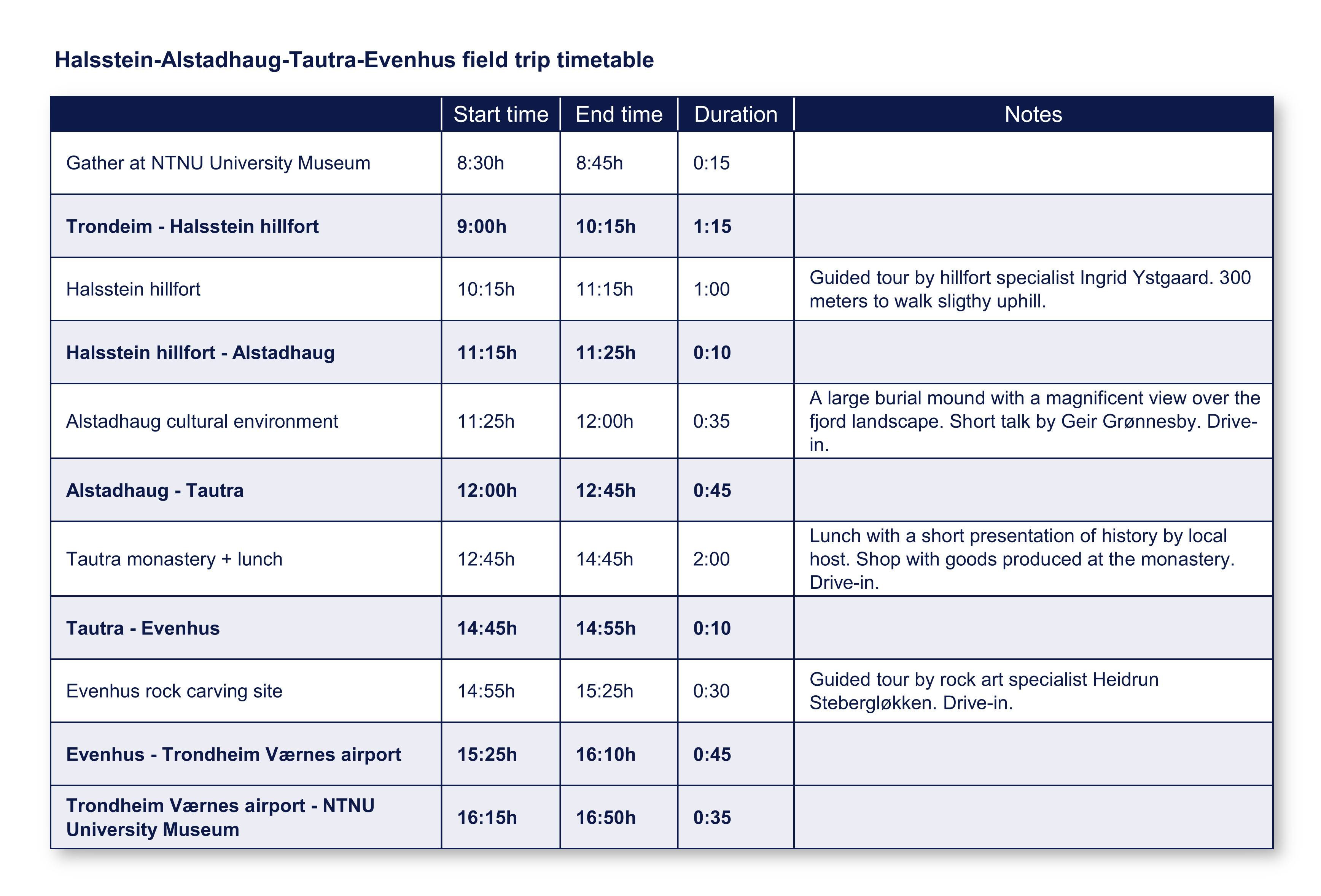
Full-day trip to Halsstein hillfort, Alstadhaug cultural environment, Tautra monastery and Evenhus rock carvings (lunch provided)
10.00-11.30
Guided tour of Trondheim (by Axel Christophersen)
To download the complete Conference Booklet, please follow the link below:
(last revision: 6th September 2025)
To download only the List of accepted papers and posters, please follow the link below:
Practical Information
The conference events will be taking place in several locations in Trondheim, as listed below:
- Welcome Reception: Dokkhuset, Dokkparken 4, 7042 Trondheim
- Conference Venue: Dokkhuset, Dokkparken 4, 7042 Trondheim
- Conference dinner: Frati Restaurant, Kongens gate 20, 7011 Trondheim
- Field trip meeting point: NTNU University Museum, Erling Skakkes gate 47B, 7012
Trondheim (click here to see the field trip timetable) - Guided tour of Trondheim meeting point: Erkebispegården, Kongsgårdsgata 1A, 7013 Trondheim.
Trondheim stands out with its progressive nature and vibrant city life, while still embodying its small town heart. It’s Norway’s third largest city, with just over 200,000 inhabitants. To help plan your trip we suggest that you take a look at the Visit Trondheim website.
Accessibility
Conference Venue
All rooms within Dokkhuset are wheelchair accessible. The entrance has step-free access. The conference is taking place entirely on the ground floor where disabled toilet facilities also are found.
Field trip
Halsstein hillfort: App. 300 meters to walk slightly uphill on a relatively uneven footpath.
Alstadhaug cultural environment: Drive-in.
Tautra monestary: Drive-in.
Evenhus rock carving site: Short walking distance but last part in uneven terrain.
Bursaries
Student/Early Career Researchers Participation Bursaries
These bursaries are intended to support students and young researchers who are interested in aerial archaeology and wish to attend and present at the AARG conference.
Please provide the following information in an email to @ AARG Chair headed with 2025 Student/Young Researcher Bursary:
- your interests in archaeology and aerial archaeology
- place of study
- the name and contact details of a supervisor or employer (email) who can provide a
reference - why you would benefit from attending the conference
- an estimate of travel costs and accomodation to attend
You should be willing to provide a poster, or an abstract for a paper under one of the conference session themes listed above.
Ukrainian Participation Bursaries
These bursaries are intended to support Ukrainian researchers who are interested in sharing their work and wish to attend and present at the AARG conference.
Please provide the following information in an email to @ AARG Chair headed with 2025 Ukrainian Participation Bursary:
- your interests in archaeology and aerial archaeology
- affiliation
- the name and contact details of a supervisor or employer (email) who can provide a reference
- an estimate of travel and accomodation costs to attend
You should be willing to provide a poster, or an abstract for a paper under one of the conference session themes listed above.
We value your privacy
Privacy Overview
| Cookie | Duration | Description |
|---|---|---|
| cookielawinfo-checkbox-analytics | 11 months | This cookie is set by GDPR Cookie Consent plugin. The cookie is used to store the user consent for the cookies in the category "Analytics". |
| cookielawinfo-checkbox-functional | 11 months | The cookie is set by GDPR cookie consent to record the user consent for the cookies in the category "Functional". |
| cookielawinfo-checkbox-necessary | 11 months | This cookie is set by GDPR Cookie Consent plugin. The cookies is used to store the user consent for the cookies in the category "Necessary". |
| cookielawinfo-checkbox-others | 11 months | This cookie is set by GDPR Cookie Consent plugin. The cookie is used to store the user consent for the cookies in the category "Other. |
| cookielawinfo-checkbox-performance | 11 months | This cookie is set by GDPR Cookie Consent plugin. The cookie is used to store the user consent for the cookies in the category "Performance". |
| viewed_cookie_policy | 11 months | The cookie is set by the GDPR Cookie Consent plugin and is used to store whether or not user has consented to the use of cookies. It does not store any personal data. |